
Where is Knud Rasmussen land?
Published:
Knud Rasmussen was a great Arctic explorer, and in honor of his exploits, a large swathe of land on the northern coast of Greenland was named after him. Looking at a modern map of Greenland, I was surprised to see much of what I knew as Knud Rasmussen Land had become Kronprins Frederik Land. Not being able to find any clear explanations for what used to count as Knud Rasmussen Land, and what counted now, I decided to dig into the story and summarize it here for any curious souls.
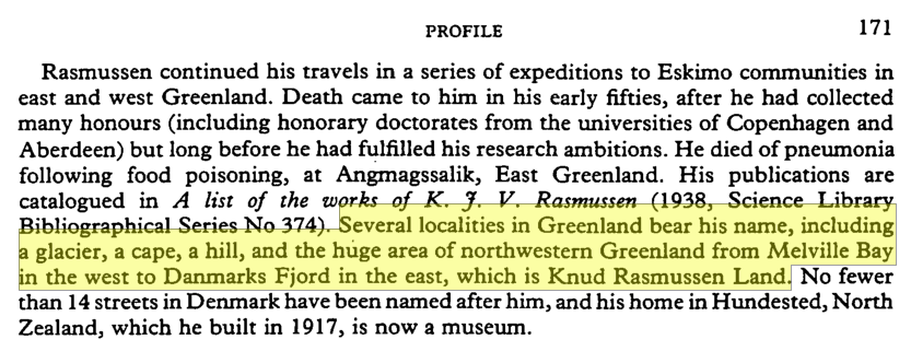
Figure 1: A reference on Knud Rasmussen land from 1984 (Gilberg, 1984).
A good reference to start with is a profile of Knud submitted to the journal Polar Record (Gilberg, 1984), which states that Knud Rasmussen land ranges “from Melville Bay in the west to Danmarks Fjord in the east“, see full quote in Fig. 1. This source might not be entirely accurate, however, as it mentions Knud receiving an honorary doctorate from the University of Aberdeen, which is likely a case of the author mistaking Aberdeen for St. Andrews. However, if we look at a map (Gyldendal, 1988) from the same decade, this definition is supported, see Fig. 2.
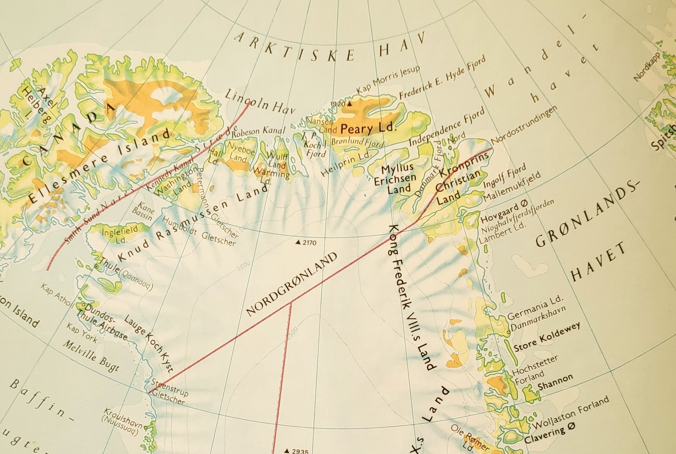
Figure 2: Map of Greenland from 1988, showing Knud Rasmussen land, Melville bay (Melville bugt) and Danmark Fjord (Gyldendal, 1988).
Melville Bay lies in the lower left of the map, while Danmarks Fjord lies at the upper center, between Mylius Erichsen Land and Kronprins Christian land. However, in 2000 the Danish crown prince Frederik and the Sirius patrol, which enforces the sovereignty of Greenland and the Danish Realm, finished Ekspedition Sirius 2000. Upon arriving back at the airport in Copenhagen, the prince was greeted by the Prime Minister of Greenland, Jonathan Motzfeldt, who declared that a portion of Northern Greenland would now be named Kronprins Frederik land. He stated that it lay “next to Knud Rasmussen Land ” (Ritzau, 2000), similar to the definition found in the Danish online lexicon Den Store Danske (Rasmussen, 2015), which states that Kronprins Frederik Land is bordered by Peary Land to the north, Kong Frederik VIII Land to the east, and Knud Rasmussen land to the west. A current map of the area (Kortforsyningen, 2020) indicates that Kronprins Frederik Land corresponds to what was previously the western half of Knud Rasmussen Land, running from Danmarks Fjord to approximately Wulff Land.
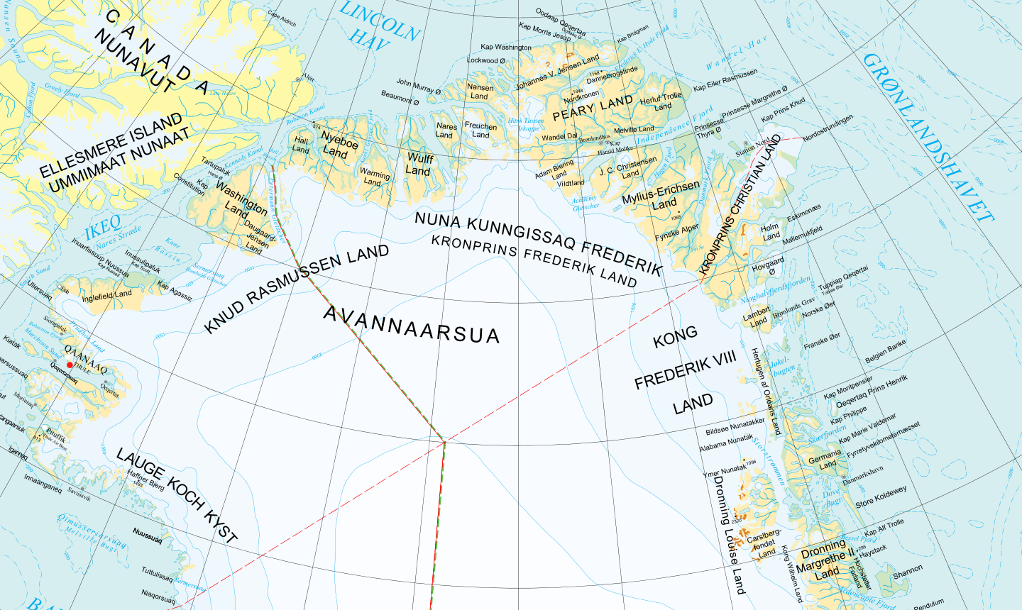
Figure 3: Current map of Greenland, indicating the border between Knud Rasmussen Land and Kronprins Frederik Land to be near Wulff land (Kortforsyningen, 2020).
So where is Knud Rasmussen Land? It would appear that it used to stretch from Melville Bay in the west to Danmarks Fjord in the east, but was reduced by half in 2000 to end at Wulff Land in the east.
References
Gilberg, R. P. (1984). Profile: Knud Rasmussen, 1879-1933. Polar Record, 22(137), 169-171.
Gyldendal. (1988). Grønland (Kalallit Nunaat). In Gyldendals Atlas, 6th Ed., 2nd print (p. 46).
Kortforsyningen. (2020). Grønland 1:10.000.000. Retrieved January 31, 2020, link
Rasmussen, R. O. (2015, January 23). Kronprins Frederik Land. Retrieved April 28, 2020, from Den Store Danske: link
Ritzau. (2000, June 14). Grønlandsk område bærer kronprinsens navn. Retrieved January 31, 2020, from Jyllands-posten.dk: link